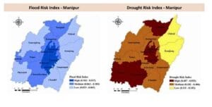
The Department of Science and Technology (DST) in its assessment report ‘District-level Climate Risk Assessment for India: Mapping Flood and Drought Risks Using IPCC Framework’ (Dasgupta, S. et al., 2024), observed that hazard-specific risk profiles at district-level help identify districts requiring urgent attention.

By Salam Rajesh
If it is any consolation for Manipur State, two of its districts in the central Manipur valley area figure among the high-risk flood and drought prone zones in India. Both Imphal West and Imphal East Districts figure in the list of high-risk zones mapped by India’s Department of Science and Technology.
Spelling out the risk assessment for the country in terms of recurring extreme floods and droughts across the country in this year and in recent past, the Department of Science and Technology (DST) in its assessment report ‘District-level Climate Risk Assessment for India: Mapping Flood and Drought Risks Using IPCC Framework’ (Dasgupta, S. et al., 2024), observed that hazard-specific risk profiles at district level help identify districts requiring urgent attention. The report was released in the national capital last week.
The district-level flood risk indices range from 0.015 to 0,688 across India, indicating the flood risks across the districts in India. The assessment indicated 51 districts in the country at ‘Very High’ flood risk category (0.440 to 0.688) while 118 districts are identified in the ‘High’ flood risk category (0.284 to 0.439).
In Manipur State, Imphal West and Imphal East Districts both figure in the ‘High’ Flood Risk Index ranging between the indices of 0.183 to 0.537, while Senapati, Noney, Jiribam and Churachandpur districts are identified in the ‘Medium’ category ranging between indices of 0.063 to 0.182, and the rest of the other districts figure in the ‘Low’ category ranging between the indices of 0.023 to 0.062 for flood risk.

The district-level drought risk indices range from 0.042 to 0.644, indicating the variation in drought risk in the districts across the country. The assessment indicated 91 districts in the ‘Very High’ drought risk category (0.510 to 0.644) while 188 districts are identified in the ‘High’ drought risk category (0.450 to 0.509).
In the Drought Risk Index, five districts in Manipur, namely, Imphal West, Imphal East, Senapati, Pherzwal and Churachandpur figures substantially in the ‘High’ risk category ranging between the indices of 0.407 to 0.553. Tamenglong, Kangpokpi, Noney, Jiribam, Bishnupur, Kakching, Tengnoupal and Chandel districts figure in the ‘Medium’ category ranging between the indices of 0.182 to 0.406. Ukhrul and Kamjong districts, however, fall under the ‘Low’ risk category ranging between the indices of 0.111 to 0.181.
Outlining the utility of the report, the DST stressed that the objectivity of the assessment is to help ‘uncover the relative contribution of flood and drought hazards, exposure, and vulnerability within each district, and to facilitate the identification of critical indicators that policy makers can utilize to prioritize interventions to mitigate or buffer the impacts of specific climate hazards’.
On its other utility, the report laid particular stress on providing ‘valuable insights to policy makers for integrating into the State Action Plan for Climate Change (SAPCC) with periodic updates of the assessments based on the evolving hazard occurrences to ensure strategies remain relevant and effective, and are aligned with the goal of sustainable and adaptive governance’.
Suggesting the pathways for both flood and drought mitigation, the report laid stress on sector-specific risk index development for creating risk indices ‘tailored’ to specific sectors such as agriculture and horticulture at State level, with particular stress on Land Use Land Cover (LULC), and the varying rainfall patterns at risk.
The report further suggested urban risk assessment to assess flood and drought risks in districts, cities, towns and villages with specific focus on the water supply, while it urged for standardized methodology application utilizing a common methodology to assess risks associated with hazards like landslides, heat stress, and compounding or cascading extreme weather events.
Further on the pathways, the report also suggested risk assessment under future climate to address the imperative of conducting risk assessments under different climate change scenarios while recognizing the ‘evolving nature of environmental challenges’.
It may be recalled that several pockets of the State experienced intensive floods during May and June earlier this month with unprecedented heavy rainfall punctuating the normal passage of the monsoons, courtesy of Cyclone Remal extending its reaches to the North East. Imphal East District experienced its worst floods in decades. Large swath of agricultural lands in Bishnupur District experienced long period of inundation, damaging crops and over flowing fish culture farms, incurring substantive income loss for the agricultural and fish farmers.
Dr Tourangbam Brajakumar Singh, Director, Directorate of Environment & Climate Change, Manipur; Dr Sanoujam Manichandra Singh, GIS Consultant; and Yengkokpam Satyajit Singh, Junior Research Officer, DoECC, represented Manipur State in the DST’s flood and drought risks assessment exercise for all the districts in India.
